|
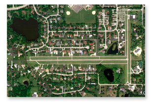 The primary runway at Brookeridge, 9/27, has 2813 feet of paved surface and is flanked by paved parallel taxiways on each side. Runway 9 has a displaced threshold of 260 feet and Runway 27 has a displaced threshold of 205 feet. Available takeoff and landing distances should be reduced accordingly. Brookeridge is also served by a secondary 1680 foot N-S restricted landing area which is available for limited use when conditions dictate that a landing on that runway might be a safer option. The airport is owned and operated by Brookeridge Aero Associates, Inc. (BAA) who maintains the runways and taxiways on BAA property, keeps the grass mowed and the snow plowed, and provides for the availability of aviation fuel to Brookeridge residents. BAA has 26 shareholders, the majority of which are current residents of Brookeridge. Operating funds for BAA come from fees charged to Brookeridge residents and tie-down tenants, as well as income from fuel sales. The primary runway at Brookeridge, 9/27, has 2813 feet of paved surface and is flanked by paved parallel taxiways on each side. Runway 9 has a displaced threshold of 260 feet and Runway 27 has a displaced threshold of 205 feet. Available takeoff and landing distances should be reduced accordingly. Brookeridge is also served by a secondary 1680 foot N-S restricted landing area which is available for limited use when conditions dictate that a landing on that runway might be a safer option. The airport is owned and operated by Brookeridge Aero Associates, Inc. (BAA) who maintains the runways and taxiways on BAA property, keeps the grass mowed and the snow plowed, and provides for the availability of aviation fuel to Brookeridge residents. BAA has 26 shareholders, the majority of which are current residents of Brookeridge. Operating funds for BAA come from fees charged to Brookeridge residents and tie-down tenants, as well as income from fuel sales.
Brookeridge is served by a private non-precision RNAV (GPS)-A instrument approach and is located beneath the 3600 foot shelf of the O’Hare Class B airspace and just west of the 1900 foot shelf of the Midway Class C airspace. IFR departure clearances with a void time are normally available from Chicago Approach via telephone if the weather does not permit a VFR departure with an airborne clearance pickup.
Our unique location in a developed suburban area requires some special operating rules to ensure that we maintain good relations with our neighbors and can continue to enjoy airpark living in a location convenient to all that a major metropolitan area has to offer. The use of the field is restricted to Brookeridge residents and others with airport rights, and their fly-in guests. Those guests must receive a briefing covering the essentials of the operating rules at Brookeridge before being granted permission to use the airport. Some of the highlights are given below.
- No commercial operations of any kind are permitted.
- No repetitious takeoffs and landings, touch and go landings, or mid-field takeoffs are allowed.
- Pattern altitude is 1600 MSL.
- All traffic is to use a basic left hand pattern for approach and landing, but either a 45 left, 45 right or a straight out departure is approved.
- Radio equipped aircraft should monitor 122.9 at all times when in the pattern, on runways or taxiways. Announce your intentions and be visually alert for non-radio-equipped aircraft.
- With calm or light wind conditions, the preferred runway is 9.
- All run-ups should be conducted adjacent to where the airplane is hangared or parked.
For more information about flying into Brookeridge, please contact Dave Rutter at 630 269-0323.
FAA INFORMATION EFFECTIVE 17 DECEMBER 2009
Location
| FAA Identifier: |
LL22 |
| Lat/Long: |
41-43-57.8800N / 087-59-57.3800W
41-43.964667N / 087-59.956333W
41.7327444 / -87.9992722
(estimated) |
| Elevation: |
750 ft. / 229 m (estimated)
750 |
| Variation: |
01W (1985) |
| From city: |
3 miles S of DOWNERS GROVE, IL |
| Time zone: |
UTC -6 (UTC -5 during Daylight Saving Time) |
| Zip code: |
60516 |
Airport Operations
| Airport use: |
Private use. Permission required prior to landing |
| Activation date: |
08/1955 |
| Sectional chart: |
CHICAGO |
| Control tower: |
no |
| ARTCC: |
CHICAGO CENTER |
| FSS: |
KANKAKEE FLIGHT SERVICE STATION |
| Attendance: |
CONTINUOUS |
| Wind indicator: |
lighted |
| Segmented circle: |
no |
| Lights: |
DUSK-DAWN
RY 9/27 NON-STANDARD EDGE INTS LIGHTING |
Airport Communications
| WX AWOS-3 at LOT (9 nm SW): |
118.525 (815-588-4802) |
| WX ASOS at MDW (12 nm E): |
PHONE 773-581-8094 |
| WX AWOS-3 at JOT (15 nm SW): |
119.975 (815-730-9560) |
| WX ASOS at DPA (15 nm NW): |
PHONE 630-584-2728 |
| WX ASOS at ORD (15 nm N): |
PHONE 773-462-0118 |
Nearby radio navigation aids
| VOR radial/distance | | VOR name | | Freq | | Var |
| ORDr193/15.9 |
|
CHICAGO O'HARE VOR/DME |
|
113.90 |
|
02E |
| JOTr050/18.2 |
|
JOLIET VORTAC |
|
112.30 |
|
02E |
| DPAr119/18.3 |
|
DUPAGE VOR/DME |
|
108.40 |
|
02E |
| CGTr303/23.4 |
|
CHICAGO HEIGHTS VORTAC |
|
114.20 |
|
02E |
| EONr339/29.3 |
|
PEOTONE VORTAC |
|
113.20 |
|
02E |
| OBKr186/29.4 |
|
NORTHBROOK VOR/DME |
|
113.00 |
|
02W |
| NDB name | | Hdg/Dist | | Freq | | Var | | ID |
| ERMIN |
|
277/7.3 |
|
332 |
|
01W |
|
HK |
.... -.- |
| KEDZI |
|
269/13.9 |
|
248 |
|
01W |
|
MX |
-- -..- |
| DEANA |
|
175/14.2 |
|
350 |
|
00E |
|
ME |
-- . |
| DEKALB |
|
113/33.9 |
|
209 |
|
02W |
|
DKB |
-.. -.- -... |
Airport Services
| Airframe service: |
NONE |
| Powerplant service: |
NONE |
Runway Information
Runway 9/27
| Dimensions: |
2772 x 150 ft. / 845 x 46 m |
| Surface: |
turf
RY HAS 40 FT WIDE STRIP OF ASPH. DOWN THE MIDDLE OF TURF RY. |
| Runway edge lights: |
medium intensity |
| |
RUNWAY 9 |
|
RUNWAY 27 |
| Traffic pattern: |
left |
|
left |
| Displaced threshold: |
463 ft.
DSPLCD THLD DUE TO OBSTACLES IN THE APPROACH ZONE. THE THLD IS BASED ON A 20 TO 1 SLOPE REQ. |
|
337 ft. |
| Obstructions: |
trees
HARD SURFACED AREA W OF THE THLD THAT IS 255 FT LONG |
|
none |
Runway 18/36
| Dimensions: |
1940 x 25 ft. / 591 x 8 m |
| Surface: |
turf
SOD RY WITH WITH 25 FT WIDE STRIP OF ASPH DOWN THE MIDDLE. |
| Operational restrictions: |
RESTRICTED LANDING AREA |
| |
RUNWAY 18 |
|
RUNWAY 36 |
| Traffic pattern: |
left |
|
left |
| Displaced threshold: |
80 ft. |
|
120 ft. |
Airport Ownership and Management from official FAA records
| Ownership: |
Privately-owned |
| Owner: |
BROOKERIDGE AERO ASSOC INC
636 86TH ST
DOWNERS GROVE, IL 60516
Phone 630-985-3837 |
| Manager: |
BOB SIEGFRIED
628 W. 86TH ST
DOWNERS GROVE, IL 60516
Phone 630-985-8502
NEAL RIDENOUR 630-985-3837 |
Airport Operational Statistics
| Aircraft based on the field: |
|
72 |
| Single engine airplanes: |
|
63 |
| Multi engine airplanes: |
|
8 |
| Ultralights: |
|
1 |
|
|
 |
|
Instrument Procedures
There are no published instrument procedures at LL22.
Some nearby airports with instrument procedures:
1C5 - Bolingbrook's Clow International Airport (6 nm W)
KLOT - Lewis University Airport (9 nm SW)
KMDW - Chicago Midway International Airport (12 nm E)
KJOT - Joliet Regional Airport (15 nm SW)
KDPA - Dupage Airport (15 nm NW)
KORD - Chicago O'Hare International Airport (15 nm N) |
